Mayrhofen Piste Map
Download Mayrhofen Piste map:
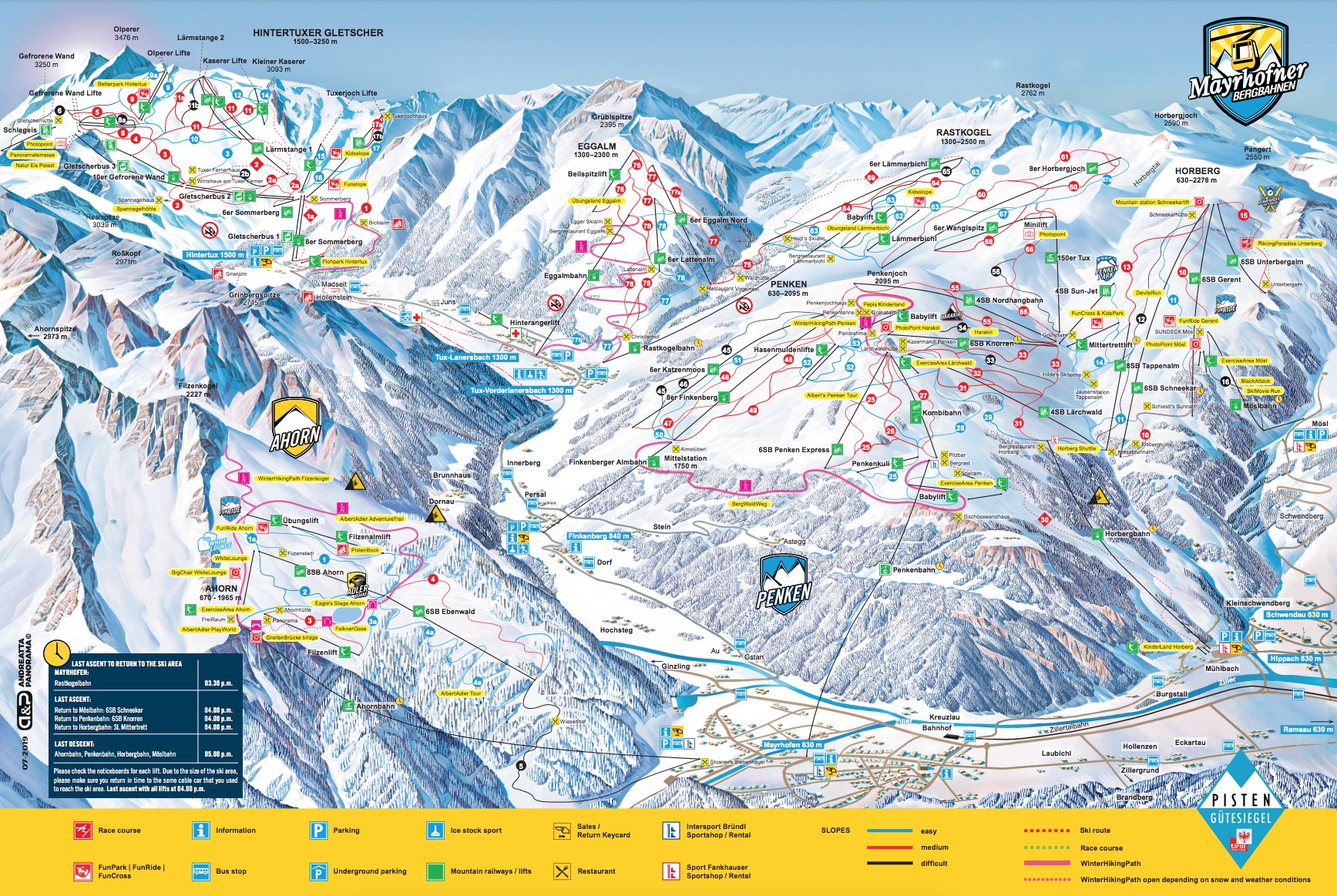
Download Mayrhofen piste map as a pdf or an image file:


Mayrhofen ski resort overview:
Mayrhofen ski resort, nestled in the Zillertal Valley in Austria, is a popular destination for winter sports enthusiasts. Known for its stunning alpine scenery and lively après-ski scene, Mayrhofen offers something for everyone - from beginner skiers to seasoned experts. The resort boasts access to 142 km of pistes, spread across the Penken, Ahorn, Rastkogel, and Eggalm mountains. A key draw for visitors is the variety of slopes available. The Penken area is famous for its more challenging terrain, including the legendary Harakiri run - the steepest groomed slope in Austria, with a daunting 78% gradient. For those seeking gentler routes, the Ahorn mountain provides wide, scenic pistes that cater to beginners and families. To plan your days on the slopes effectively, it’s essential to consult the Mayrhofen piste map, which clearly outlines the runs, lifts, and mountain facilities. The ski infrastructure in Mayrhofen is modern and efficient, with high-speed gondolas like the Penkenbahn swiftly transporting skiers from the village to the mountain. Snow reliability is generally good, thanks to high-altitude slopes and artificial snow systems. For those looking to extend their adventures, the Zillertal Superskipass offers access to a vast network of 535km of pistes across the wider Zillertal region. Mayrhofen’s après-ski scene is another highlight. The town buzzes with activity in the evenings, offering a mix of traditional Austrian huts, stylish bars, and nightclubs. Popular spots like the Ice Bar and Brückenstadl are known for their lively atmosphere and flowing drinks. However, Mayrhofen isn’t without its drawbacks. During peak season, the resort can become quite crowded, leading to lift queues and busy slopes. Some intermediate skiers may find the Penken area a bit too challenging, while the Ahorn side might feel limited for those seeking variety. Navigating between mountain areas can also require some planning, making the Mayrhofen piste map an invaluable tool. Overall, Mayrhofen ski resort strikes a solid balance between thrilling skiing experiences and vibrant off-slope entertainment. Whether you’re chasing adrenaline-pumping descents or cozy mountain moments, this Austrian gem has plenty to offer.
Quick facts about Mayrhofen:
| Mayrhofen resort altitude: | 655m | ||
| Mayrhofen Piste altitude: | 630m-2500m | ||
| Number of lifts in Mayrhofen: | 44 | ||
| KM of pistes in Mayrhofen: | 142km | ||
| Longest piste in Mayrhofen: | 5.5km (Ahorn Valley Run) | ||
| Total pisted runs in Mayrhofen: | 56 | ||
| Green pistes: | N/A | ||
| Blue pistes: | 44km | 31% | |
| Red pistes: | 66km | 46% | |
| Black pistes: | 32km | 23% |
How do I get to Mayrhofen?
| Nearest airport to Mayrhofen: | Innsbruck Airport (INN) 70km | Find flights | |
| Transfer time to Mayrhofen: | 2hrs | Airport Transfers |
How much does a Mayrhofen lift pass cost?
| Adult: €76, Youth: €61, child: €34.50 | ||
| Indicative one day lift pass price. Daily cost normally cheaper when purchased for longer period. |
Download Mayrhofen Piste map:
Download Mayrhofen piste map as a pdf or an image file: